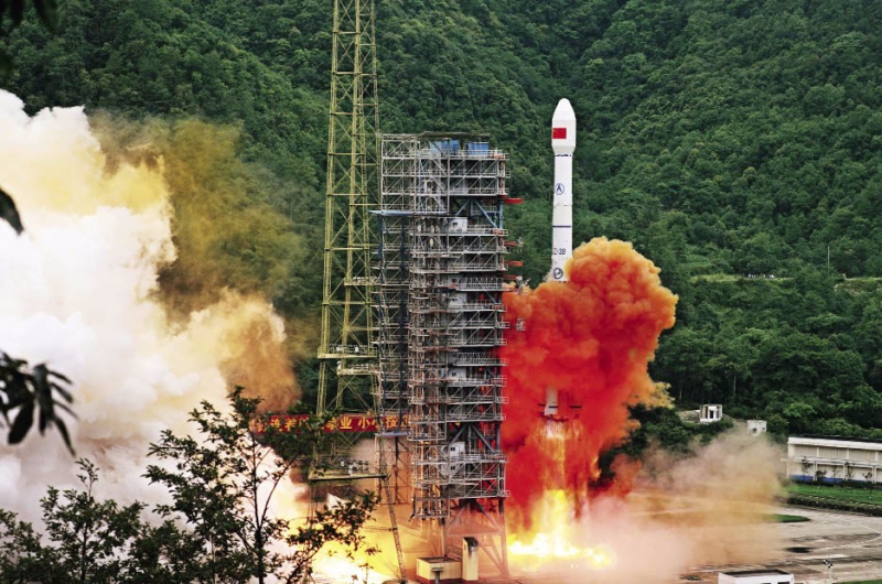
A carrier rocket carrying the last satellite of the BeiDou system blasts off from the Xichang Satellite Launch Center in Sichuan Province on June 23, 2020, marking the completion of the global deployment of China’s own navigation system.
In fact, since late 2018, BDS has begun to provide global services. As of now, the four satellites of BDS-1 have all been decommissioned. With its remarkable progress in system construction, application and promotion, and global development, alongside its expanding global coverage and improving service capacity, BDS is rising to the status of one of the world’s top-tier satellite navigation systems.
Compatibility, a Dominant Global Trend
Lately, reports about American spy plane pilots using BDS as a backup to GPS have caught lots of attention. This indicates that most of Global Navigation Satellite System (GNSS) products worldwide feature multi-system compatibility and interoperability, a dominant trend now, also a result of market competition.
China has been attaching great importance to BDS’s construction and application and set its development goal to become a world leading satellite navigation system, providing continuous, stable, and reliable service. Meanwhile, BDS has also proactively integrated with the GNSS family in a bid to make its service available to more global users.
Since it started to provide services to the Asia-Pacific region in late 2011, China has made public detailed documentation about BDS including the BDS System Signal In Space Interface Control Document (ICD), service performance specification, and the application service architecture, inviting manufacturers worldwide to adopt BDS. Today, it has become common practice for major GNSS providers to make their services compatible and interoperable with BDS. Therefore, it is a small wonder that the aforementioned U.S. pilots’ watches were compatible with the system.
Many foreign users indicate that BDS has allowed them quicker positioning and a better user experience.

At the 4th International Innovation & Entrepreneurship Expo held on December 20-22, 2019, parents explain the BeiDou system to their children.
International Exchanges and Cooperation
The principle that “BDS is developed by China, and dedicated to the world,” has been adhered to since the birth of the system, aiming to make it better serve the world and benefit humankind.
As a member of the International Committee on Global Navigation Satellite Systems (ICG), China has participated in all ICG meetings, and successfully hosted the Seventh ICG Meeting in 2012, and released the Joint Statement of Global Navigation Satellite Systems for the first time. In 2018, China hosted the 13th ICG Meeting, and released the Xi’an Initiative to advocate joint development of satellite navigation. Meanwhile, China has resorted to various international conferences and multilateral cooperation platforms to promote compatibility and interoperability of multiple navigation systems.
As one of the four major GNSS providers, China has stuck to the principle of open cooperation and resource sharing in developing BDS, and actively carried out international exchanges and cooperation, trying to advance compatibility and interoperability of the BeiDou system with other major satellite navigation systems in the world. In May 2015, China and Russia signed the Joint Statement on Compatibility and Interoperability between China’s BDS and Russia’s GLONASS; in November 2017, The Joint Statement of BDS and GPS Signal Compatibility and Interoperability was signed between China and the United States. The multi-system compatibility and interoperability has allowed global users to enjoy more efficient and reliable navigation services.
By jointly formulating standards with other countries, advancing multi-system compatibility, and expanding service fields, China has actively participated in international cooperation, and shared its development achievements in satellite navigation with other countries, thus promoting global economic development and improving people’s livelihood.
Broad Application Fields
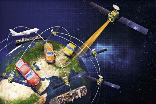
BDS has applications in many fields including transportation, public security, agriculture, forestry, water conservancy, surveying and exploration, weather forecasting, telecommunication, power dispatching, and disaster relief and mitigation. Meanwhile, the BDS-based navigation service has also been widely found in the mass consumption field and sharing economy after being adopted by manufacturers of smart mobile terminals as well as e-business and positioning service providers, thus profoundly changing people’s lives.
In the field of transportation, BDS has been applied in the monitoring of key transportation processes, road infrastructure safety, and high-precision real-time positioning and dispatching in ports. As of now, more than seven million commercial vehicles, 30,000 postal and express delivery vehicles, about 80,000 buses in 36 cities, over 3,200 navigation facilities on inland rivers, and over 2,900 maritime navigation facilities are using BDS, forming the world’s largest dynamic monitoring system for commercial vehicles, which has greatly improved the monitoring management efficiency and the safety of transportation.
In the field of disaster mitigation and relief, more than 45,000 BDS terminals have been installed. Through the short message and location reporting function of BDS, disaster-hit regions can timely report information about the location, disaster specification, and relief required. Meanwhile, civil affairs departments at various levels can also monitor disaster relief supplies, thus greatly improving the management and dispatching of nationwide disaster relief supplies.
Apart from infusing vitality to the traditional sectors, BDS has also fueled emerging industries. In the future, the system will be deeply integrated with sectors like 5G mobile communication, narrow-band Internet of Things (IoT), and artificial intelligence. This means 5G chips will be equipped with a high-precision positioning function enabled by BDS; smart phones, automobiles, robots, and IoT terminals will realize such functions in applications such as automatic map generation, intelligent path planning, automatic environment recognition, and remote platform monitoring. Meanwhile, new application fields will be further explored, including asset tracking, personnel positioning, cellular auxiliary positioning, cold chain transportation, and intelligent manhole covers.
BDS also helps provide solutions for tricky problems occurring in daily life, for example the parking anarchy of shared bikes. Many people are not aware of the fact that they are monitored when riding a shared bike. If they fail to park the bike in a designated area, they would be spotted.
For fishermen who are at sea all year round, the short message function of BDS has become a life-saver. Now more than 70,000 fishing vessels and law-enforcement boats in China have been equipped with BDS terminals, which makes it possible for tens of thousands of people to get timely rescue in a crisis.
Meanwhile, the driver’s dream of “no slowing down at a toll station” is coming true in Nanchang, the capital city of Jiangxi Province. Owing to the high-precision positioning function of BDS, a car’s exact itinerary can be mapped. Based on that, the road toll is calculated and automatically deducted from the driver’s payment card. Of course, both the car and the toll settlement system have to adopt BDS terminals for this solution to work.
At the end of 2019, China’s first self-driving high-speed railway linking Beijing and Zhangjiakou, the two host cities of the 2022 Winter Olympic Games, went into operation. Due to its applied cutting-edge technologies, the line, boasting a speed of 350 kilometers per hour, is also dubbed as “the smartest railway.” Benefiting from the high-precision positioning function of BDS, the bullet train running on the rail line can realize a precise stop with a margin of error less than 10 cm.
Even more amazing applications are found in Mawan Port of Shenzhen City, Guangdong Province. Facilitated by BDS, 80 container trucks can realize continuous and accurate positioning throughout the whole day in their running across the whole port area, presenting people a glimpse of the future smart port.
Meanwhile, owing to its deep integration with the 5G technology, BDS is expected to play a big part in the deve-lopment of a slew of new sectors such as smart cities, smart manufacturing, smart households, and smart agriculture.
Serving the World
To better serve global users, China sped up the construction of BDS’s global network deployment. After the basic completion of BDS-3, the system began to provide services to overseas users in late 2018. With its stable, reliable, and precise navigation service, BDS is benefiting global social development.
Now, BDS has been widely applied in many fields internationally, for example confirmation of land rights, precision agriculture, warehousing, and logistics in ASEAN countries; airport time service and offshore piling in South Asian countries; power line inspection in East European countries; and land surveying in Africa.
To better serve users in ASEAN countries, members of the League of Arab States, and Central Asian countries, China has carried out a series of activities together with related sides, including the China-Arab States BDS Cooperation Forum and China-Central Asia BDS Cooperation Forum. The China-Arab BDS/GNSS Center was also established in Tunisia, to provide locals with training and education service.
Now BDS is helping expedite technical innovation across the globe, thus making people’s lives more convenient. It has been successfully applied in cross-border transportation, confirmation of land rights, precision agriculture, digitalized construction, and smart port initiatives in ASEAN countries, South Asia, West Asia, and Africa. Domestically produced BeiDou-based products have been exported to more than 120 countries and regions.
In 2020, BDS will be all set to serve the whole world. It has been the consistent pursuit of the operators of BDS to better serve global users with high-quality, high-precision navigation services. China is committed to further improving the BeiDou system, promoting compatibility and interoperability with other navigation systems, and sharing its development achievements with other countries.
CHEN BIAO and QI XIAOJUN are chiefs of publicity at the publicity research and communication center of BDS.


