| Newsmore | ||||||
|
| Culturemore | ||||||
|
| Tourismmore | ||||||
|
| Economymore | ||||||
|

| Lifemore | ||||||
|
| Around Chinamore | ||||||
|

| Newsmore | ||||||
|
| Culturemore | ||||||
|
| Tourismmore | ||||||
|
| Economymore | ||||||
|
| Lifemore | ||||||
|
| Around Chinamore | ||||||
|
| Economy |
| The Beidou Satellite Navigation System By staff reporter ZHOU CHANG ON April 14 when a 7.1-magnitude earthquake rocked Yushu County, Qinghai Province, telecommunication signals were completely cut off in the stricken region. Then more than 100 user terminals of the Beidou Satellite Navigation System were rushed to the site and handed to the relief workers and rescue personnel. The machine was unveiled in 2008 after an 8.0-magnitude earthquake struck Sichuan Province. At that time, the China National Satellite Navigation and Positioning Application Administration Center equipped the relief forces with over 1,000 terminals of the Beidou system, allowing them to communicate between different locations and contact relief headquarters. Beidou (Big Dipper) is a name given by ancient Chinese astronomers to the seven brightest stars of the Great Bear constellation. As this set of stars was used in navigation to locate the Polaris, Beidou serves as a metaphor for the function of the satellite navigation system. Along with Beidou, the world currently has three other systems – the Global Positioning System (GPS) of the U.S., the GLONASS of Russia and the Galileo System of Europe.
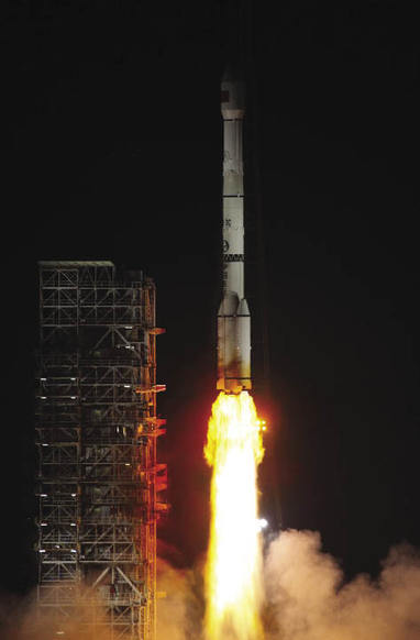
Building the System The U.S. began to research GPS technology back in the 1970s and finally implemented it in 1984. The project cost US $20 billion. Russia set out to build its GLONASS System in 1976, which saw its heyday in 1995 when 24 satellites went into operation simultaneously around the Earth. At that time China was still in the process of developing large passenger aircraft and long- and medium-range rockets for carrying LEO or MEO man-made satellites. It seemed a far-off dream to establish its own three-dimensional real-time satellite navigation and positioning system. “Dual-satellite positioning is feasible in theory and possible in practice,” claimed Chen Fangyun, late chief designer of the Beidou system. In 1983 he proposed utilizing geosynchronous satellites to set up China’s own satellite navigation system. On May 25, 2003, the third Beidou-1 satellite was launched into the orbit at the Xichang Satellite Launch Center (XSLC), making the establishment possible of a complete satellite navigation system. The first-generation Beidou adopted Chen Fangyun’s proposal of dual-satellite positioning, but its coverage was limited to China and the surrounding areas. The second-generation Beidou system is known as Beidou-2. As the third Beidou-2 satellite was successfully launched into its scheduled orbit on January 17, 2010, China began to enjoy its own global navigation system. China is currently building the Compass system. It plans to launch five geostationary orbit satellites and 30 non-geostationary orbit satellites. According to the plan, the system will cover the Asia-Pacific Region around 2012, providing services such as navigation, time signal and short message services. Before 2020, the Beidou system will provide global navigation services. The Most Accurate Time Signal “Global satellite navigation involves a combination of aerospace and atomic clock technology, representing a unity of time and space,” introduced Liu Qixu, chief engineer of China National Satellite Navigation and Positioning Application Administration Center. “The accuracy of a satellite positioning system depends on the accuracy of atomic clock.” Atomic clock research had experienced a 20-year stagnation in China. The country used to entirely depend on imported high-precision timing instruments and received only GPS time. “In the 1970s we had ample funding for research, but later financial support began to dry up until there was virtually none, so we were only able to conduct basic research,” recalled Wang Yiqiu, one of the earliest Chinese researchers on the atomic clock. In the 21st century, research on atomic clock technology and national time frequency system resumed. Thus far, Beidou is the most accurate among the global timing services that have published their accuracy data. It provides both one-way and two-way timing services. The precision in the one-way system is 100 ns (nanoseconds, equaling to 1 billionth of a second), and 20ns in the two-way service. Under the one-way mode, the terminal user can accomplish time synchronization by receiving navigation signals instead of connecting with the central earth station. Under the two-way mode, the terminal user needs to interact with the central station and apply for timing. The central station will calculate the time differences and send the data back to the user via satellite. The Beidou high-precision timing system has been incorporated into China’s power grid, supervising the status of all clocks in the network at any given time. Furthermore, it can automatically control all clocks in the network, realizing remote time intervention and adjustment. Therefore, China has solved the problem of time synchronization over the power network and holds independent intellectual property rights for the technology. Wide Applications Along with disaster relief, Beidou is also applied in the field of financial trading. As the terminal computers have a two-second delay from the server, financial hackers often use the time lag to manipulate stock prices. For a stock in an upward trend, for example, when an investor prepares to buy, the gains probably are over, as the host computer is already on a downward trend. The time difference might allow financial hackers to skim large quantities of money from common investors. So it is vital to install accurate atomic clocks like Beidou in both the host machine and all sub-machines of the financial trading system. Since every machine receives financial information at one time, hacking of the system or malicious market manipulations can be prevented. The Compass System has an enormous commercial potential. China is the largest market for shipping, automobile and mobile phone. Statistics show that at the end of 2009, the Compass System had over 60,000 users and provided 330 million positioning services, 220 million communication services, and 30 million two-way timing services. Its reliability is better than the designed 99.98 percent. The system has been successfully applied in the fields of water conservancy and hydropower engineering, marine fisheries, communications and transportation, weather forecasting, land surveying and mapping, disaster relief and public security. Meanwhile, the future of Beidou’s industrialization is clear. On December 26, 2009, China’s first industrial base of satellite navigation application industry settled in Shanghai, according to the strategic cooperation framework agreement signed between the Surveying and Mapping Bureau of the Headquarters of the General Staff of the People’s Liberation Army and Shanghai’s Minhang District Government. This is a substantial step toward the industrialization of Beidou’s civil use.
Beidou Milestones October 31, 2000: The first Beidou-1 navigation satellite is successfully launched. December 21, 2000: The second Beidou-1 navigation satellite is launched. May 25, 2003: The third Beidou-1 navigation satellite is sent into orbit, completing the Beidou-1 satellite navigation and positioning system. April 14, 2007: The first Beidou-2 is sent to space. April 15, 2009: The second Beidou-2 is launched. At 0:12 on January 17, 2010: The third Beidou-2 is sent to space by Long March-3C carrier rocket from the Xichang Satellite Launch Center. |
| VOL.59 NO.12 December 2010 | Advertise on Site | Contact Us |